Tuesday, December 30, 2003
Colloquial Mapping
Among Matt’s ideas for leveraging social-networking software is an amalgam of online mapping services and friend-based recommendations.
Create a mapping service that allows the community to suggest alternate paths along with reasons for it. Suggest the routes to be taken as dictated by the software's GIS information, but also list user suggestions, and to ensure quality, also add ratings of user suggestions by others.
Whereas Yahoo! Maps can lead you astray by taking the most direct, but slowest, route, Matt says, locals may be able to recommend the most efficient way to get from A to B — a level of experience and insight that mapping software inherently lacks. Interesting idea.
Monday, December 29, 2003
Treasure Island, Arr
A map of Treasure Island, from an online edition of Robert Louis Stevenson’s novel. The map is from the first edition, if I’m not mistaken. (via The Cartoonist)
Sunday, December 28, 2003
Which GPS?
Believe it or not, I don’t own a GPS receiver. Nor do I know where to start in terms of researching which unit to buy when the time comes. So I’ll be reading this Ask Slashdot thread with considerable interest (via muxway). For my part, my ideal GPS would be reasonably Mac-compatible, have Canadian topo maps available, and be able to speak in UTM — I need something for the trail, not for the road. Any suggestions?
Wednesday, December 24, 2003
Maps of the Lower Rio Grande
Cartography of the Lower Rio Grande:
The series of maps in this section present a graphic illustration of the history of the Lower Rio Grande region. Individually, the maps illustrate who settled here and where they settled; they also indicate the destinations of persons or groups traveling through this region. Collectively, the maps highlight the cohesive unity of the Lower Rio Grande.
(via Plep, again)
Topography of Mars
Another nice bit of off-world cartography: a topographical map of Mars generated by the Mars Orbiter Laser Altimeter (MOLA). Click on the map for more detail. (via Plep/APOD)
Tuesday, December 23, 2003
Zip Code Visualizer
A seriously cool thing: a Java-based Zip code visualizer that highlights a given area of the U.S. as you enter each digit of the five-number Zip code. (via MetaFilter)
Recent California Earthquakes
The USGS has maps of recent earthquake activity. Yesterday’s quake shows up on the California-Nevada map. (via Here Be Dragons)
Saturday, December 13, 2003
Map Lovers Tribe
I’ve set up a tribe for map lovers on Tribe.net, called, originally enough, Map Lovers. If you’re reading this and you’re a member of Tribe.net, you’ll probably want to sign up.
Friday, December 12, 2003
Tube Map as Flowchart Template
Okay, this London tube map thing is going a little bit too far: Process Mapping by Tube — via Kottke.
Pont’s Maps of Scotland
An online collection of 77 maps by Timothy Pont. “Among the National Library of Scotland's greatest treasures are the earliest surviving detailed maps of Scotland, made by Timothy Pont over 400 years ago, in the 1580s and 1590s.” (via Plep)
London Underground Remixed
Okay, that’s it! Enough with the London tube maps already! You people are just too
Wednesday, December 10, 2003
History of Cartography
Richard sends along a link to the home page of the History of Cartography Project, which is an ongoing, comprehensive multivolume history of mapping from the year dot to now. Expensive — a single volume costs US$150. And while I’m at it, the University of Chicago Press’s cartography and geography catalogue looks
New URL for Map History/History of Cartography
Tony Campbell, who maintains the Map History/History of Cartography site (see previous entry), writes to say that the site is moving to a new URL: www.maphistory.info. Time to update our bookmarks, links and sidebars.
Underground London
Faithful submitter Huw sends along this nice piece from Heritage magazine about underground London — which is, according to the piece, more than just the oft-covered-on-this-site London Underground. With a map showing underground rivers, sewers, bomb shelters and even Roman excavations. (The page is part of a frames-based web site and as such is rather bare.)
Interactive Maps of London, Ontario
Behind again in my posting; time to catch up. Mike sends along a link to the Maps of London — that’s London, Ontario.
Mike says: “This is the London Ontario official city map. Not sure if you have referenced it before. It is fully interactive, zoomable, has overlays for bus routes, schools, identifying objects on the map, etc., plus the ability to switch to aerial photos of most of the city at the scale of the map you were viewing. A fantastic site. Just click on the city maps Javascript link under Interactive Maps on the right of the page. Best use so far: looking for houses and apartments and seeing the aerial photo of the building and knowing it’s a house, walk up or highrise.”
 The Map Room is a blog about maps by
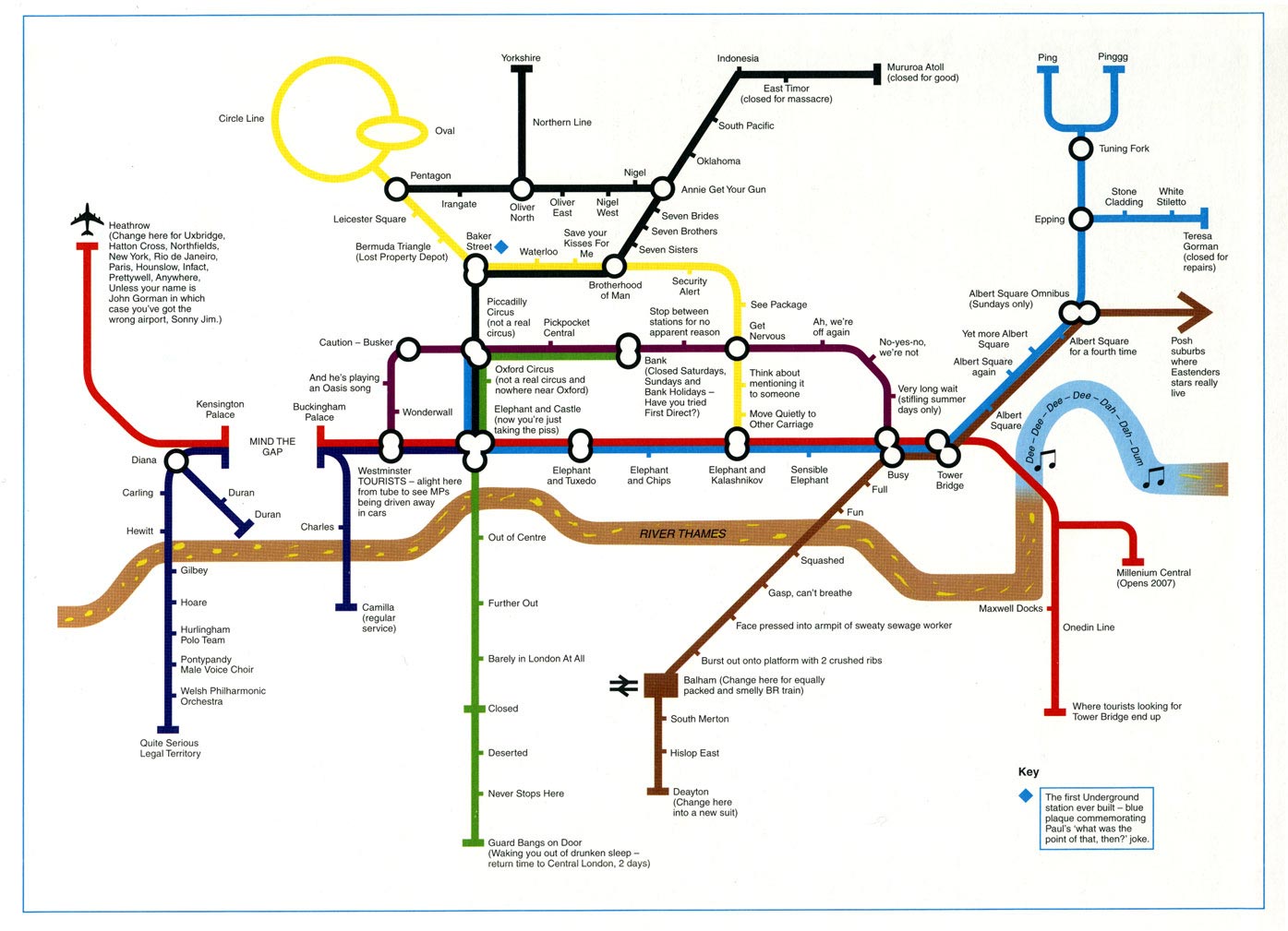