Pearcy’s 38 States
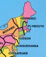 In the 1970s, geography professor C. Etzel Pearcy proposed reconfiguring the United States into 38 states that were, in his view, more physically and culturally coherent. This page has the story — and, more importantly for our purposes, the map.
When Pearcy realigned the U.S., he gave high priority to population density, location of cities, lines of transportation, land relief, and size and shape of individual States.… Each major city which fell into the “straddling” category is neatly tucked within the boundaries of a new State. Pearcy tried to place a major metropolitan area in the center of each State. St. Louis is in the center of the State of Osage, Chicago is centered in the State of Dearborn.
Via Things Magazine; thanks also to Owen.

Comments
blog comments powered by Disqus