Japanese Rail and Subway Maps
Nicolas Jasson has submitted a frighteningly impressive number of links to Japanese rail and transit maps. His e-mail, which I’ve edited to incorporate links into the text, is as follows:
I am very interested in railways and transit and Japanese mapping is usually very accurate and always up-to-date. A few samples:
JR East Tokyo local network [PDF]. This is a fraction of the whole rail network of the Tokyo area: it shows only the JR-East network, not the subways, not the numerous private railways.
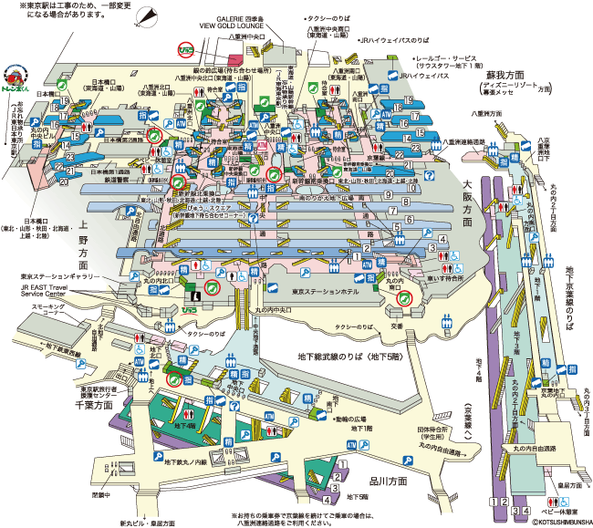
Official 3D map of Tokyo station [PDF] requires Japanese-enabled Adobe Reader, otherwise as a GIF.
Mapion is probably Japan’s best map website, recently upgraded with Mapion BB (BroadBand). The Tokyo station area with Mapion, part of a fully-interactive map coverting the whole of Japan, every single building or house is accurately shown, together with its number in the block (the basis of the address system).
The new version of the Tokyo subway map, where each station has been allocated a code, the first letter for the line, and a sequential number: English version [PDF]; all Japanese (1, 2) [PDF]; central Tokyo [PDF], with added graphics for the principal monuments.
There is a vast quantity of transit maps on the web, like this one for the Hankyu, a local rail company operating in the Kansai region. [second link added]
Map of the last surviving tram line in Tokyo. Original Japanese map.
A knowledge of Japanese is required for many of these links. I’m astonished at the work Nicolas put into this.

Comments
blog comments powered by Disqus