Oh No, Not Again: Tracking Hurricane Rita
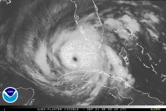 There are several resources for keeping tabs on the next volley of tropical storms to hit the Gulf of Mexico and Atlantic Ocean. NOAA’s Storm Tracker page for Rita and Philippe has tracking maps and satellite photos. Google Earth users can download a live hurricane tracker that lists all current storms worldwide (download here; via Google Earth Blog). For Google Maps users, the Central Florida Hurricane Center again has a tracking map for Rita as a mashup (via Google Maps Mania). The established hurricane information sites that tracked Katrina before it hit will obviously be worth having a look at again.
See previous entries about Hurricane Katrina.
Update, 9/21 at 8 AM: James notes that you can track Rita by selecting “Current Hurricanes” in the ArcWeb Hurricane Katrina Disaster Viewer.
Update, 10:30 AM: Hurricane Rita tracking map from Weather Underground (via Kathryn Cramer).

Comments
blog comments powered by Disqus