Soviet Spies Map the World
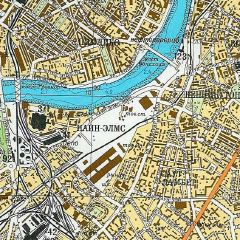 During the Cold War, the Soviet Union compiled topographic maps of virtually every corner of the world, to the extent that they are the only topo maps available for certain countries. The maps were both standardized and accurate; they were made for military purposes, so the same, specific information was needed regardless of which area was being mapped. John Davies has been studying these maps, in particular on how the Soviet Union mapped the United Kingdom. His site includes scans of a few of the maps as well as a two-part paper that, in part, deals with how the Soviets compiled their information (and whether they violated Ordnance Survey Crown Copyright in the process). Tremendously interesting stuff. Via Cartography.
See previous entry: Soviet Topo Maps; Old Russian Maps.

Comments
blog comments powered by Disqus