The Western World’s Oldest Map
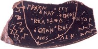 In today’s edition of the Daily Telegraph, an article about the oldest map in the western world: the Soleto Map, unearthed two years ago in southern Italy, which dates to 500 BC. The map, which is on a postage-stamp-sized fragment of glazed terracotta (an “ostrakon”), depicts the Salentine peninsula (the heel of Italy’s boot), is written in Greek script (though the language is mostly Messapian), and marks towns that still exist today.
This is, apparently, the first physical evidence that the Greeks were making maps before the Romans did. (The Chinese were making maps before this, according to the article; and there were earlier maps in the Meditteranean and Middle East, according to a post on MapHist. I think the point is that this is the first map in the so-called Western Civilization tradition.)
Tony Campbell notes (on MapHist) that the Soleto Map was the focus of a conference earlier this year.

Comments
blog comments powered by Disqus