A Look Back at the Chinese Map Controversy
 A couple of weeks ago, an announcement that a Chinese map had been discovered that “proved” that the Chinese had “discovered” the Americas before Columbus swept the world news media. The Economist broke the story on the 16th; see also Reuters (at CNN), National Geographic News, and Time Asia.
Shortly thereafter, followup stories began appearing that called this extraordinary claim into question. Because I was insufficiently on the ball to report it in detail — my mistake was to try for an easily procrastinated single comprehensive post rather than to post frequent updates — I’ll sum it up for you now.
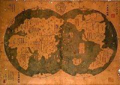
In a nutshell, this started in 2001, when a lawyer and collector named Liu Gang bought a map from a dealer in Shanghai for $500. He had it looked at by experts, but did not have a clear sense of what it was. After reading Gavin Menzies’s book, 1421: The Year the Chinese Discovered America, he (with Menzies’s help) concluded that the map, which dated itself to 1763, was a reprint of a 1418 map that proved that the Chinese were aware of (and discovered) much of the New World.
But first, a bit about Menzies, who claims, both in his book and on his web site, that the Chinese admiral Zheng He, who voyaged to East Africa, also made several long voyages of discovery in the 1420s, including to Australia, New Zealand and the Americas (thereby discovering America long before Columbus). The Menzies theory is dismissed by serious scholars, who point to selective use of evidence and give it about the same credibility as Hapgood’s theories about the Piri Reis map. For an example, see Robert Finlay’s dismissive review of the book. Outside of his followers, Menzies appears to be seen as something of a charlatan or a quack.
Anyway, Menzies seized upon Liu’s map as evidence of his theory — never mind the fact that the map was purportedly dated three years before Menzies claimed Zheng visited the New World. A piece of the map, Liu says, is being sent for carbon dating, though that leaves aside the question of proving that a map dated 1763 is an accurate reproduction of an identical, though now nonexistent, map from 1418.
The academic reaction to Liu’s map was that it was either (a) an 18th-century map that drew its information from European sources, or (b) a more recent forgery, with the consensus of opinion tilting strongly towards the latter. They point to anachronistic uses of language on the map (using a term for Christianity that was not in use prior to the sixteenth century, for example), the fact that fifteenth-century Chinese cartographers would not have known about the kind of projection used in the map, and the details on the map itself — too many continental interior details for a map purportedly made by sailors, along with errors that correspond all too well to known European mapping errors.
For Chinese scholars’ reactions, see Gong Yingyang in the New York Times, Mao Peiqi in this Interfax story (via GeoCarta), and Jin Guoping in his blog (translated from here). Jin points out that the map uses simplified characters in use only in the last 50 years.
For more on the response, see the Guardian, Here Be Dragons, MetaFilter, National Geographic News, and Reuters (via Swissinfo).
I’m indebted to the members of MapHist for their cogent discussion of the map and its veracity early on in the cycle. Would that I could have gotten my act together on this sooner.

Comments
blog comments powered by Disqus