Exhibition Roundup: Fort Worth, Texas; Hannibal, Missouri
 Patterns of Progress, an exhibition of Texas bird’s-eye-view maps — previously covered here — is now running at the Amon Carter Museum in Fort Worth, Texas until May 28.
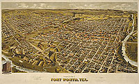
More than sixty highly detailed and oversized prints in this special exhibition will offer a chronicle of one of the greatest periods of urban growth in Texas history. … These prints are not only surprisingly accurate historical documents but intricate works of art as well. They were drawn by hand using, most often, two-point perspective to produce a three-dimensional rendering. According to research, eleven different itinerant artists drew and published at least sixty-seven bird’s-eye views of Texas cities.
Via GeoCarta.
Meanwhile, an exhibition of maps from the Missouri State Archives, Mapping Missouri, will be on display at two locations in Hannibal, Missouri until April 23. “Drawing from such diverse examples as the land survey maps made by Antoine Soulard in St. Louis from 1796-1806, to the computer generated Lewis and Clark maps created by Jim Harlan and the University of Missouri’s Geographic Resources Center in 2002, this exhibit explores the history of cartography in Missouri and the role maps have played in our everyday lives.”

Comments
blog comments powered by Disqus