Ask.com Relief Maps
I didn’t pay much attention when Ask.com unveiled its own mapping service a little while back, but now they’ve done something that no other online mapping service has done yet: they’ve added a relief map layer.
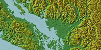
It only works on the higher zoom layers, and it doesn’t work with Safari (which gets a different mapping engine), but you have to admit, it’s both neat and unique. (You can also toggle the label layer on and off, so you can have roads and cities as well; I turned it off for this screen capture.)
More: All Points Blog; Anything Geospatial; Search Engine Watch.
Meanwhile, Edward notes that the Ask.com relief maps have a significant flaw — one that the Dutch would certainly notice: any land below sea level is shown as being underwater.

Comments
blog comments powered by Disqus