Severe Weather Imagery for Google Earth
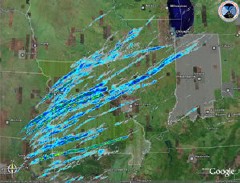 Real-time data (or at least near real-time data) exists in the online mapping world, just not the real-time satellite and aerial imagery that uninformed people get exercised about — take traffic congestion data, for example. Weather data is another possibility for satellite imagery, and radar images are even more up to date. Which brings me to the real-time severe weather imagery for Google Earth being made available by NOAA’s National Severe Storms Laboratory as part of their Warning Decision Support System — Integrated Information project. Essentially, you’re getting KMZ files of satellite and radar imagery layers. This sounds handy — incredibly practical for stormtracking and the like. I’ll have to give it a try. Via Google Earth Blog.

Comments
blog comments powered by Disqus