The Living Map
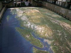 Cartography draws our attention to the Living Map, a huge, three-dimensional map of British Columbia now on display as part of the “B.C. Experience” exhibition that just opened in Victoria’s Crystal Garden. The 40-foot-by-74-foot map even models the curvature of the earth. More on the Living Map on the B.C. Experience web site; Solid Terrain Modeling (STM), which constructed the model, has a gallery of high-resolution images on their press page.

Comments
blog comments powered by Disqus