Geotagging Indirectly: ZoneTag, Sony
A bit more on geotagging — adding geographic coordinates to digital photos. One the one hand there’s having a GPS-enabled camera; on the other there’s adding latitude and longitude manually. Some options in between the two extremes are emerging which strike me as a little unorthodox: they get the job done, purportedly, but do so in unorthodox ways. One does it by identifying cell towers, the other by matching timestamps.
For example, ZoneTag, a Yahoo! skunkworks project, which is for photos sent to Flickr from cameraphones (specifically, Nokia Series 60 phones at the moment). It adds tags based on the cell phone network the phone is sending from, including the cell tower’s ID; Flickr users can subsequently tag their photos with more location data to identify where that tower is based. It’s a mix of cell-network and user-submitted data to approximate location. Via Yahoo! Local & Maps Blog.
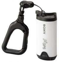 Then there’s the Sony GPS-CS1, a little GPS device that geotags indirectly by using software to match the photo’s timestamp with the location read by the GPS receiver at that instant. Nice if it works. Announced yesterday; available September for about $150. (Does it only work with Sony cameras?) Here’s the press release; also coverage from Engadget, Gizmodo and GPS Review.

Comments
blog comments powered by Disqus