The Middle East Redrawn
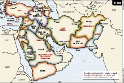
An article by Ralph Peters in the June 2006 issue of the Armed Forces Journal imagines a redrawn map of the Middle East, where borders are shifted and new states are created to address local — and, thanks to the attention given to the Israel-Palestine situation, less well-known — injustices: ethnic groups separated by international borders are united, stateless minorities are given homelands (e.g. Kurdistan). No more than a thought experiment, but one bound to generate controversy. Via MapHist (where it already has).
For similar thought experiments, see previous entries: Pearcy’s 38 States; Question: What-If Political Boundaries?

Comments
blog comments powered by Disqus