Computer-Generated Electoral Districts
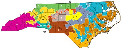
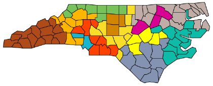
An American Scientist article from 1996 discusses the ways in which computer algorithms might improve — or at least depoliticize — how electoral district boundaries are drawn. Taking North Carolina’s congressional districts as an example, the author, Brian Hayes, looks at some of the ways — some less ideal than others — a computer might redraw the boundaries given certain criteria. Above: the first map shows the somewhat gerrymandered status quo at the time the article was written; the second map is an example of computer-generated redistricting. Via Andrew Sullivan.
Previously: Congressional District Maps; U.S. Electoral District Ballot Initiatives; State Redistricting Pages; Texas Congressional Redistricting.

Comments
blog comments powered by Disqus