Historic Pittsburgh Map Collection
 Historic Pittsburgh is a site featuring documents, maps and books from the University of Pittsburgh and other Pittsburgh-area collections. Their Map Collections section has four large series of map scans available:
- Geodetic and topographic survey maps for Pittsburgh between 1923 and 1961;
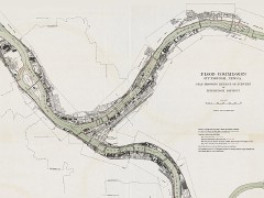
- Maps from the 1912 Flood Commission for Pittsburgh;
- Plat maps for the greater Pittsburgh area from 1872 to 1939 in the G. M. Hopkins collection; and
- The Warrantee Atlas of Allegheny County from 1914.
The total is over 1,300 plates (mostly from the Hopkins collection). Thanks to peacay for the links.

Comments
blog comments powered by Disqus