The Quebec-Labrador Border
GeoCarta notes the news that a boundary dispute between the Canadian provinces of Quebec and Newfoundland and Labrador has flared up over Quebec wildlife maps that show part of Labrador as belonging to Quebec.
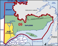
This is not new. The Quebec-Labrador boundary has been in dispute since 1902, and a formal Privy Council decision in 1927, setting the present boundary, has not been accepted by everyone. Indeed, Quebec’s official maps frequently show two boundaries to southern Labrador, their unilateral boundary and the real boundary, labelled “Tracé de 1927 du Conseil privé (non définitif),” despite the fact that no one other than the province disputes it, and past provincial commissions have agreed that nothing could be done about it. (Then again, Quebec separatists’ maps include all of Labrador.) I live in Quebec, so I know.
For more on the Labrador boundary, see this page from Newfoundland and Labrador Heritage, the Canadian Encyclopedia, this page from Library and Archives Canada, this page from Labrador Straits, the Wikipedia entry on Labrador, this collection of legal documents relating to the dispute and this page from Marianopolis College.
Categories: Mapping Errors
![The Map Room: A Weblog About Maps [logo]](/maproom/images/title_inverse.jpg)
The website of Transports Quebec (http://www.mtq.gouv.qc.ca/en/information/carte_routiere/index.asp) does the same thing with its official road map. For that matter, so does the paper version of the map, at least the latest one I have.
Lloyd Spivak | 01/26/2007 at 9:41 AM | #
Showing the two boundaries is a very legitimate way of mapping a disputed boundary.
… The British have always used watershed to define boundaries. The Quebec - Labrador boundary is a exception to this approach. The ‘Tracé de 1927 du Conseil privé (non définitif)’ reflects the boundary that does not follow this British rule.
As for your claim that separatist maps include all of Labrador, you should provide maps that explicitly show your statement. I hope that others will not consider you personal opinions as facts.
Jacques Gélinas | 01/29/2007 at 5:08 PM | #
All right. I recall TV coverage of a PQ rally that had a laser light show that displayed a map of Quebec that included Labrador. It would have been either in the late 1980s or early to mid 1990s.
I generally tend not to say things without cause. But if you’re looking for a smoking gun rather than a recollection, I can’t help you.
Jonathan Crowe | 01/29/2007 at 5:18 PM | #
Jonathan,
Not looking for a smoking gun. Your example on the PQ rally is valid and does show a misconception of the province’s geographic space as seen by mal-informed Separatist. Separatist should not be associated with the process of map making and thus I though your statement was somewhat politically inclined. (Cartographer should be politically neutral)
And as a cartographer I stand by the claim that showing both boundaries is ‘cartographically’ acceptable. However in the case of the map shown, the debate should be on whether or not to colour the depicted area beyond the official boundary. Again as a cartographer the mistake lies in that portion of the cartographic representation.
Regards,
Jacques Gélinas
Jacques Gélinas | 01/29/2007 at 7:25 PM | #
One last twist…
Maps produced by The government of Québec follow their official boundary definition (their boundary follows the geographical break between the watershed that goes to the Labrador sea and the one that flows to the Gulf of St-Lawrence). So the debate lies also in the fact that an official Quebec maps (as the one shown) differ from an official Canadian map… Keep in mind that this debate has been ongoing (since 1927) and is not considered as a closed and shut issue by the present government.
Jacques Gélinas | 01/29/2007 at 9:11 PM | #
Hello,
I wrote a analysis about this issue (in french) on my blog, if you want to take a look at it, here’s my web page :
http://lebloguedevincent.blogspot.com/2007/02/lambigut-qubcoise-et-le-labrador.html
Vincent Robidas | 02/15/2007 at 12:48 PM | #