Local Logging Maps
Though only in fits and starts so far, I’ve been slowly working my way through the maps in my local archives’ collection. We have what you might expect: a mixed bag of local topo and cadastral maps, both current and antique, and some maps donated by locals that themselves aren’t local — old road maps, for example.
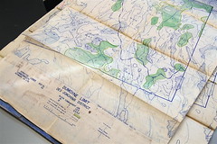 But one thing we do have in great quantity: a whole whack of maps that appear to have emanated from the E. B. Eddy Company’s logging operations in my county. I took a few photos on Saturday to give you a sense of what they look like: 1, 2, 3. Most of the ones I’ve gone through so far date from the 1960s, and they’re printed in blue ink (that smears, let me tell you), with coloured highlights indicating areas of interest, on fairly cheap paper — these were maps printed for work, not for posterity.
I’m going to have a hell of a time trying to organize these things into some kind of serial order. Unfolding and flattening them for better storage is going to be fun, too. If you know anything about this kind of map, I’d love to hear from you.
Previously: Question: Cataloguing a Map Collection?

Comments
blog comments powered by Disqus