Turn the Map Over
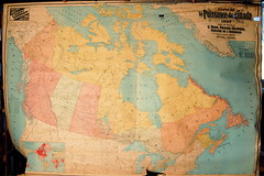 My friend Robert, who’s the president of the local historical society, stopped by this afternoon with an interesting find — something he salvaged from a pile of junk that the town hall was about to throw out. It was a rolled wall map. We unrolled it, and discovered it was a 1907 map of Canada issued by the Department of the Interior. It was torn in several places, and there was some water damage at the top, but nothing was missing and it was otherwise in good shape. It was a map I liked: good colour, showing the rail lines and contemporary provincial boundaries. I could see getting it dry mounted to sort of gloss over the rips.
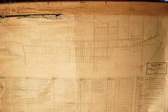 But then we turned the map over and saw what was on the other side. And that was a lot more interesting. Because on the back of this 1907 map of Canada was a map of my town, Shawville, drawn in September 1931 by Arthur W. Argue of the Shawville Water Works Department. The map showed water lines, connections, hydrants, and all the owners and tenants for each lot, and was a reasonably good map of the town circa 1931 besides. Argue used the back side of a map that in 1931 was already out of date to draw his map — I wonder why he did that. Was large paper hard to come by, or was it because it was already on a roll? Curious.
The 1907 map of Canada was mass produced given the quality of the paper alone; the map on the other side is one of a kind.

Comments
blog comments powered by Disqus