Author Reinterprets Maps, Claims Portuguese Discovered Australia
 A new book claims that a Portuguese fleet discovered Australia in 1522, nearly 250 years before Captain Cook arrived at Botany Bay: Reuters, Daily Telegraph. The claim, by author Peter Trickett, is based on a reinterpretation of a 16th-century French atlas which, he says, was based on a misreading of captured or stolen Portuguese portolan charts. From the Telegraph article:
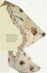
Modern scholars had noticed that one of [the atlas’s maps] closely resembles the coastline of Queensland, aside from a point where it suddenly shoots out at a right angle for a distance of about 900 miles.
After studying the map himself, Mr Trickett came up with a new theory — that the French map-makers had wrongly spliced together two of the Portuguese charts they were copying from.
With the help of a computer expert, he divided the map in two and rotated the lower half by 90 degrees.
Suddenly the chart fitted almost exactly the east coast of Australia and the south coast as far as Kangaroo Island, off present day South Australia.
Tricket argues that the Portuguese kept the discovery a secret for competitive reasons. I’m not equipped to evaluate the veracity of this claim; I will say that this whole nonsense with Gavin Menzies and Liu Gang and their claim of a map that proves that the Chinese discovered America (see previous entry) makes any such claim hard to believe. We’ll see how it shakes out. Via MapHist; thanks to Tony and Stefan.

Comments
blog comments powered by Disqus