Google Reverts to Pre-Katrina New Orleans Imagery
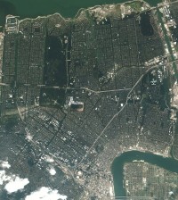 Google has apparently replaced post-Katrina images of New Orleans with imagery from before the hurricane clobbered the city, and people are upset about that, the AP reports (choose your source for the same article: Boston Globe, Guardian, Houston Chronicle, Huffington Post, USA Today).
My reaction to this depends on what this old imagery replaces. There are (at least) two possibilities, and I don’t know which is true.
If it replaces imagery of New Orleans underwater, then reverting to old imagery might be the least worst option: New Orleans is still devastated, but it’s dry. It takes a while to update satellite and aerial imagery, so if there hasn’t been a flyover since the storm, it might simply be past time to revert to non-disaster imagery. If the city was on fire during the flyover, you wouldn’t keep the blaze burning on the image server for years afterward, would you?
But, if it replaces imagery taken of a dry, damaged New Orleans some time after Katrina, then someone has some explaining to do. I don’t, however, assume a conspiracy without actual evidence of said conspiracy.
Or did the “Katrina” button just get removed? (It was removed at some point, because it’s not there now. When, I don’t know.)
Thanks to Maggie for the tip.
Previously: Hurricane Katrina: Google Maps and Other Imagery.
Update, 3/31 at 10:40 AM: Frank reports that the imagery change actually took place last September. (See, we were paying attention.) The post-Katrina imagery was, as I thought, right after the storm and was lower-quality than the older, pre-Katrina imagery. So when you think about it, the pre-Katrina imagery is more useful than the alternative, notwithstanding any symbolic implications. New imagery would, of course, be nice.
Update, 3/31 at 3:30 PM: A congressman is harrumphing about this, too (via The Earth Is Square).

Comments
blog comments powered by Disqus