Landsat Image Mosaic of Antarctica
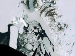 The Landsat Image Mosaic of Antarctica “combines nearly 1100 hand-selected Landsat satellite scenes that are being digitally woven together to create a single, seamless, cloud-free image of the Antarctic continent — the most detailed color representation of this vast and frozen landmass ever produced,” according to the press release. Not very accessible based on my cursory glance: Landsat imagery does not appear to be available in a format usable by mere mortals; the LIMA mosaics page doesn’t appear to work in Firefox or Safari; and the Atlas of Antarctic Research, an online GIS viewer, doesn’t seem to have the abovementioned imagery available as a layer. Am I missing something? Via Very Spatial.
Previously: Atlas of Antarctic Research (link to atlas now dead; see above for new link).

Comments
blog comments powered by Disqus