Maps for the Visually Impaired
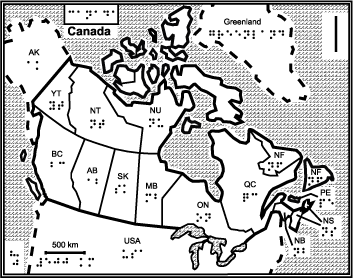 Presenting spatial information to those who cannot see is not, as you might think at first glance, a lost cause: a section of Natural Resources Canada’s web site is dedicated to providing (and researching methods of providing) maps for the blind. Most are extremely low-resolution, and make little or no use of colour: these are tactile maps, meant to be felt — with the lines and letters enhanced with a thermal enhancer — or seen by people with limited vision. Lines are thick; symbols are large; information density is by necessity limited. The site has a section on mapping procedures — how to make such maps. And the research section has interesting material on audio-tactile haptic maps — maps that make sounds relevant to what you pass over, read out names of streets and buildings and so forth (some examples). Via ResourceShelf; thanks to peacay for the tip.
Previously: Maps and Directions for the Blind; Online Maps for the Visually Impaired.

Comments
blog comments powered by Disqus