Nikolas Schiller
 Yesterday’s Washington Post had a major piece about Nikolas Schiller, who’s been doing artful things with aerial photography and doing his best to stay under the web’s collective radar. (Sorry.) Excerpts from the Post article:
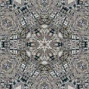
Schiller barely pauses on the way to his computer, which he fires up to reveal hundreds of his map creations. They are places you know — the Mall, Adams Morgan, Georgetown, plus other U.S. cities and war-torn ones abroad. But the streetscapes — photographed from above at a resolution fine enough to just make out cars and people — have been warped and woven into kaleidoscopic mosaics, arabesques, spheres. […]
Since Google Earth appeared a few years ago — and countless office hours were wasted as people mouse-clicked to their own back yards (“Lookee, there’s the deck!”) — the starting point of Schiller’s creations has been familiar. But he doesn’t use Google. He goes to the source, the bird’s-eye rendering of America placed in the public domain by the U.S. Geological Survey.
Then it gets complicated. On his computer he will take a swatch of a neighborhood, then he will tessellate it by creating mirrored repetitions, then he may impose radial geometry on the repetitions. The result is elaborate abstraction assembled from realistic detail, ready for framing at 5 by 3½ feet.
“It’s just a cool idea,” says Dave Roberts, a USGS cartographer. “I’ve never seen anything like that before.”
Despite his attempts at keeping a low profile, Schiller’s web site is readily accessible, and has lots and lots of examples of his handiwork.

Comments
blog comments powered by Disqus