U.S. Army’s Field Manual on Map Reading and Navigation
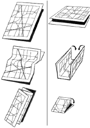 This is a real find: the U.S. Army field manual for map reading and navigation, including those things related to maps that the Army felt a soldier should know. (Which, according to chapter one, seems to be quite a bit, at all levels.) Including, for example, a thorough description of UTM and a surprising amount of detail on aerial photography, but also an appendix on something as basic as how to fold a map (see image at right) — which, when you think about it, is something that really does need explaining! I haven’t gotten through it all yet — there’s so much there that is interesting and, in many cases, informative, that it will take a while. Too bad it’s in Army style: it’d otherwise make a pretty good educational reference. Neat, neat stuff nonetheless. Via Catholicgauze.

Comments
blog comments powered by Disqus