Real-Time Satellite Imagery: EarthNow vs. The Simpsons
 Live, accessible satellite imagery is a pipe dream, but EarthNow is probably as close as we’ll ever get:
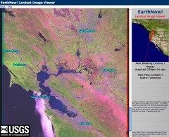
 it’s not live, but (updated; see below) it is real-time — just delayed a few hours. It’s essentially a Java applet that displays the feed from the Landsat-5 and Landsat-7 satellites as they make their passes overhead; the images I saw just now were from earlier this afternoon. Via All Points Blog and Free GeoTools.
At 250-metre resolution, they’re unlikely to raise any security or privacy concerns. (Remember, this is satellite imagery, not aerial photography.) The popular view of satellite and aerial imagery is more or less encapsulated by The Simpsons:
Via Google Karten and Valleywag.
Previously: Satellite Misconceptions.
Update, 5/2: E-mail from Rachel Kurz of the Landsat Project: “Just for clarification … When the EarthNow! viewer says that the pass you are watching is LIVE, it actually is the live downlink from the satellite to the Landsat Ground Station in Sioux Falls, South Dakota.”

Comments
blog comments powered by Disqus