Angling in Troubled Waters
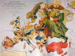 Catholicgauze calls this map — “Angling in Troubled Waters,” an 1899 map by Fred W. Rose — “one of the best historical maps I have ever seen.” The map, which apparently is reprinted in New Worlds: Maps from the Age of Discovery, crams historical figures into the territories of European countries in a way that reminds me of The Illustrated Enemy (see previous entry).
Update, 5/17 at 1:30 PM: Fixed link.

Comments
blog comments powered by Disqus