Subglacial Lakes and Rivers in Antarctica
A recent National Science Foundation report discusses what should be done to explore and preserve a system of lakes and rivers beneath the Antarctic ice cap; of interest to us is this map of that system.
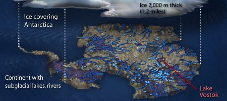
Ice-penetrating radar and other studies have identified more than 145 subglacial lakes under the ice of the southernmost continent, including one under the South Pole itself. The largest known is Lake Vostok, which has a surface area of roughly 14,000 square kilometers (5,400 square miles), making it roughly the size of Lake Ontario in North America. […] Scientific evidence further indicates that these environments comprise vast watersheds some of which appear to be connected by rivers and streams that flow freely beneath the ice sheet, which in most places is more than two miles thick.
Via Kottke.

Comments
blog comments powered by Disqus