Google, Censorship and Washington, D.C.
Nikolas Schiller writes to point out an article in today’s Washington Post about Google’s updated imagery of Washington, D.C., and how Google massaged the fact that the most recent imagery available — 2005 imagery from the USGS — censored several sensitive locations in the U.S. capital:
The newer photos on Google’s map of Washington are from 2005 Geological Survey satellite images released in March. Those photos were updated from images released in 2002 and are much more detailed. Vehicles have structure. People have shadows. Buildings have shingles. Trees have branches.
But in the 2005 Geological Survey images, the White House is blocked out by a white rectangle, and when you zoom in on the Capitol and the Washington Monument, they become a flurry of dots. Rather than use those photos, Google used uncensored images of the area, including the White House and Capitol, from a commercial vendor.
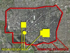 Those commercial images date from 2002 and are at a lower resolution, but they do not censor the sites in question. Nikolas pointed out the censored areas in a blog post earlier this month. He objects to the fact that the censored area is far larger than the area redacted in the USGS imagery; Stefan points out, however, that “Google does not itself mix and match imagery at the sub-tile level. … [T]he only tool Google is left with is a broad brush, and that it sometimes is forced to use it when confronted with governmental censorship as in DC (hence the inability to evade a de facto censorship policy).”
The moral panic over satellite imagery and national security continues.

Comments
blog comments powered by Disqus