The Cantino Planisphere
Timothy Thomas writes:
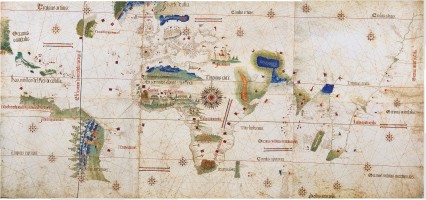
There are no good, hi-res images of the 1502 Cantino Planisphere — one of the earliest maps from the age of discovery. This object is included in the current exhibition at the Smithsonian’s Sackler Gallery in Washington, DC.
The exhibition website includes a flash image of the Cantino World Map with a zoom function. I stitched together the complete image with screenshots. This was laborious, but, I believe, useful. I also think it is the only hi-res example of the Cantino Planisphere now available for potentially general use (there is no copyright on this work).
I have uploaded my work (3525×1650 PNG file, 11.9 MB) here. You may download it and/or link to it [on The Map Room] to spread it among interested parties. Please credit me for the assemblage of the same. I am a graduate student in the humanities at the University of Chicago.
There is also an excellent monograph on the planisphere here.
Update, 10 July 2012: I have received several inquiries asking for a copy of the high-resolution image referred to above, since the link is now defunct. I don’t have a copy; try here. Also, stop confusing me with Mr. Thomas, whom I quote above.

Comments
blog comments powered by Disqus