Which Waldseemüller?
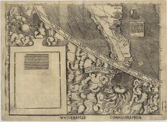 Which Waldseemüller map is “America’s birth certificate” (i.e., the first map to label the New World as “America”)? Is it the one the last copy of which is now on display at the Library of Congress? Or, as the Providence Journal suggests (mirror), is it another Waldseemüller map acquired by Brown University in 1901, which may or may not have been published before the Library of Congress’s map? And Tony Campbell writes on MapHist, “Just to help this along, it is worth reminding the participants about the globe gores in Minnesota’s James Ford Bell Library, included in their exhibition last October, entitled ‘The Map that Named America, 1507-2007.’ That is not mentioned in the current article.” (More on the Bell Library’s gores.)
Previously: Upcoming Books on Waldseemüller.

Comments
blog comments powered by Disqus