GE E1050 Digital Camera: Built-in Geotagging
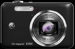 I make a point of noting when digital cameras with built-in GPS and geotagging are announced. And, while GE isn’t exactly known for consumer digital cameras, its new E1050 camera does have built-in GPS for in-camera geotagging, which I find interesting. Apart from the $249 price tag, the 10-megapixel camera otherwise seems par for the course for the industry right now. Digital Photography Review, Engadget, Free Geography Tools.
Update (February 2): Does this damn thing have GPS or not? Richard writes, “According to Engadget, the reality is actually a bit more complicated, Engadget says the E1050 will use Geotate, a new fast-capture and post-process GPS technology.” And the Engadget post in question says:
Well, to say that the E1050 has true GPS would not be totally accurate — but the very features it lacks are what make it possible to incorporate geotagging capabilities in the first place. You see, this model only contains a GPS radio courtesy of New Zealand-based Rakon, but no baseband chip to process the data in order to create a “fix”; rather, an NXP Semiconductor spinoff called Geotate provides server-connected software that does the heavy-duty calculations once photos have been transferred over. This results in almost no hit to battery life or endless waits for a solid fix.
It works like this: every time the shutter is triggered, the camera’s memory card briefly captures the raw data from the GPS radio, associating it with each photo. Then, once the pictures have been imported into Geotate’s proprietary client, auxiliary location data is downloaded from a central server, which is then synthesized with the camera data using local resources to establish actual coordinates.
Richard’s post explains more:
Geotate has devised a tiny GPS radio that only records the raw GPS signals for a short time window (200ms) when you take a photo. It doesn’t do any location calculation at all. When you download the JPEG images with embedded raw signal information, it contacts the Geotate server on the net to determine the necessary information about where the GPS satellites would have been at the time the photo was taken, and then runs the calculation (it’s not clear whether locally or on the remote server) in order to determine, based on the signal strength, what the actual location was.

Comments
blog comments powered by Disqus