Restoring the Texaco Map
The Texaco Map was a large-scale replica of Rand McNally’s New York state road map on display — underfoot — under the Tent of Tomorrow at the New York State Pavillion during the 1964-1965 World’s Fair. The map comprised 567 panels, each weighing 400 pounds (181 kg), took up 9,000 square feet (836 m2), and cost $1 million at the time.
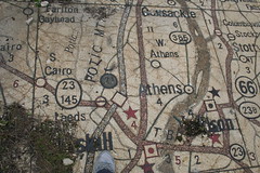 Since then, the map has been exposed to the elements and has been gradually falling apart. This page has pictures of the map, both during its heyday and during its decay.
While much of the map is beyond repair, efforts are now under way to restore at least part of the map. (Here’s a story from the Queens Chronicle from last May.) And now some of the tiles have been put on display during their restoration, the Times Ledger reports (via MapHist). The exhibition, Back on the Map: Revisiting the New York State Pavilion at the 1964/65 World’s Fair, opened last Sunday at the Queens Museum of Art and runs through May 4 (via Gothamist). The exhibition website has an interactive view of the map in its present state.
Flickr photo credit: aliyan824.

Comments
blog comments powered by Disqus