Shaded Relief World Map and Flex Projector
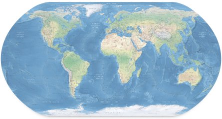
Tom Patterson of Shaded Relief wrote in to announce his new project, a physical map of the world. As was the case with his relief map of the United States, it’s free and freely available in several formats, including a Zoomify-powered online version. The map’s home page also discusses the techniques behind the map — essentially, it’s an attempt to do digitally what to date has still been done best using manual art techniques. Of note is the fact that the map uses a unique projection, developed using new software:
A unique feature of the Physical Map of the World is its projection. Rather than using a traditional projection, such as the Miller or Robinson, or the Winkel Tripel now favored by National Geographic, it uses an entirely new projection created with Flex Projector, the first-ever software for designing custom map projections. The Natural Earth projection is a pseudocylindrical projection designed specifically for presenting Natural Earth II environmental data (discussed next), from which it takes its name. The Natural Earth projection combines characteristics of the Robinson and Kavraiskiy VII projections and compares well to them in regard to map distortion.
Flex Projector is a cross-platform Java application; the current alpha version is 0.31.
Previously: Shaded Relief; New, Free Physical Map of the United States.

Comments
blog comments powered by Disqus