Contour Lines and Other Stories: A Google Roundup
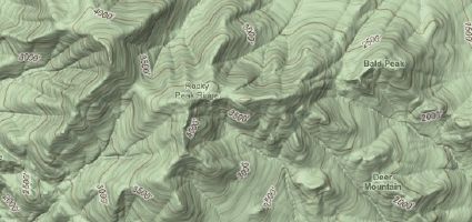
Contour lines have been added to Google Maps’s terrain map layer, which adds its their usefulness (especially, for example, in a mountain context).
But it has some way to go before it’s a suitable replacement for a topo map; Chad notes that a lot of other details are not included: “One thing that is missing … where is the water? There should be two creeks going by the town. Now while this is a ‘that is pretty to look at’ feature, this is not good for any serious use. It is missing a lot of details and landmarks for hiking and biking. I would not use this beyond a basic reference.”
I will also note that the relief shading is a little pixellated at the zoom levels at which the contour lines appear.
In other, older Google Maps-related news that occurred over the past month or so and that I’m only getting to now:
- Public transit directions have been added for Białystok (Poland), Perth (Australia) and New Jersey Transit.
- Google Maps data is now user-editable; here’s a video tutorial and the FAQ.
- Thirteen cities and a national park have been added to Street View.
- Rafe Needleman reports that, according to a source, Street View will be coming to Google Earth (Digital Earth Blog).
- Street View has been added to the Google Maps API.
- A way to add text and labels to maps within the Google Maps API (Google Maps API Blog).
- The Google Chart API now includes maps — let a thousand choropleth maps bloom (Mapperz). (Nikolas Schiller complains that it leaves out the District of Columbia.)
- There is now an official Google Maps blog in French: BloGoMaps (RenaLId).
- Recent imagery and layer updates for Google Earth and Maps include roads in 94 new countries.

Comments
blog comments powered by Disqus