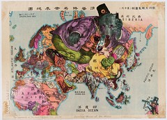
A Japanese Caricature Map of the World
 BibliOdyssey provides another example of what I suppose is called a caricature map: these are maps where representative caricatures are twisted into the shapes of the countries they are meant to represent. This one comes from Japan circa 1914.
In this entry, peacay also provides links to earlier posts of his that deal with these maps, and there turn out to be quite a few of them (such as this one). Checking my own archives, I note that I have a few as well: Streets of London; The Illustrated Enemy; Angling in Troubled Waters. This certainly appears to have been a popular form of illustration in the late nineteenth and early twentieth centuries.

Comments
blog comments powered by Disqus