Inuit Tactile Maps
Middle Savagery has a post about tactile maps, particularly as practiced by the Inuit:
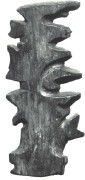
The Inuit made songs, but they also made maps. These were often sketched in snow or sand, but some of them were sketched on paper with pencil for European explorers, and were intelligible to these Westerners. These are interesting in comparable abstractions of space (thus directly addressing Whitridge’s question about the space/place binary) but I am more interested in the 3D wood carvings of the East Greenland coastline, with the details of inlets and islands in sculptural relief. These could be employed by at night in conjunction with the stars, feeling your way along the coastline, navigating at an intimate scale.
Via La Cartoteca.
Previously: Driftwood Map.

Comments
blog comments powered by Disqus