Arctic Maritime Jurisdiction Map
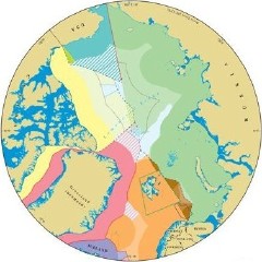 Durham University’s International Boundaries Research Unit has produced a map of the frequently overlapping boundaries, jurisdictions and claims of various countries in the Arctic. In the wake of Russia’s planting a flag on the seabed under the North Pole, in preparation for a claim that their continental shelf includes the Pole, it’s expected that the question of who controls what up there will be increasingly urgent. The PDF map “identifies known claims and agreed boundaries, plus potential areas that might be claimed in the future.” Canada’s claim to the entire Arctic Ocean up to the North Pole east of 141° W is mentioned in the notes but not depicted, for example; what we mainly see is territorial waters, exclusive economic zones, and claimed continental shelves. Thanks to Marc for the link.
Update: Reuters article.

Comments
blog comments powered by Disqus