The Repopulation of New Orleans
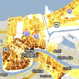 The Greater New Orleans Community Data Center’s repopulation map shows the extent to which New Orleans’s neighbourhoods have recovered post-Katrina, using the following indicators: mail pickups and Road Home grant recipients (“stay and rebuild” vs. “sell to the State”). Via James.

Comments
blog comments powered by Disqus