More Canadian Election Maps
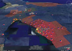 Cedric Sam has put together maps of the 2008 federal election results as Google Earth layers (at right, a screenshot). It’s well done: the riding are coloured to make a choropleth map, and contain pie charts to measure popular vote at a glance. Via Ogle Earth.
The Toronto Star has put together maps of the results in the Greater Toronto Area — seven so far — which you can get to from this post and this post. Heat maps showing the popular vote for each party in each riding, turnout rates, second-place parties and margins of victory are all mapped, using Google Maps as a base.
Previously: Interactive Maps of the Canadian Federal Election.

Comments
blog comments powered by Disqus