World War II Escape Maps
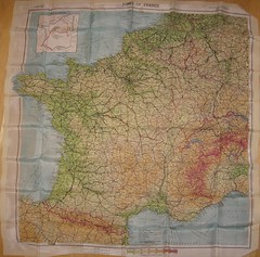 Over the past few months there has been some discussion on MapHist about “escape maps” — maps handed out to Allied pilots and air crews during World War II, printed on fabric (cloth, silk or rayon) and intended to be hid on their person in case of capture, to aid in their escape. The idea sounded fascinating; I made a mental note for a future post.
This morning, Sean Gillies posted photos of his grandfather’s escape maps. “Yesterday, I received in the mail my grandfather’s cloth escape maps of France, Holland, Belgium, Luxembourg, and Germany. He flew a Piper Cub for the US Army, mainly shuttling brass between England and France. Never used, the maps went from a pocket in his jacket to an envelope in a foot locker; they’re in great condition.”
As it turns out, there are actually (at least) two Web sites about WWII escape maps; each has a collection of scans. U.S. Cloth Maps of World War II is less comprehensive than WWII Escape Maps; the latter includes maps from American, British and Australian services.

Comments
blog comments powered by Disqus