Even More Caricature Maps
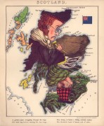 Also via MapHist, collections of caricature maps from a couple of libraries. The Library of Congress has scans of William Harvey’s Geographical Fun, circa 1868 (at right, from that book, Scotland). And a search of the University of Amsterdam Library’s map collection reveals a number of examples of the form.
Previously: Adidas’s Impossible Map; More Caricature Maps from World War I; A Japanese Caricature Map of the World; Angling in Troubled Waters.

Comments
blog comments powered by Disqus