Accessible Transit Maps
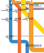 Randy Plemel has been making stroller- and wheelchair-accessible maps of transit systems — in other words, maps where only the accessible stations are shown; non-accessible stations are erased. After earlier takes on the London Underground and New York Subway, Randy has put together another New York map — this time based on Massimo Vignelli’s controversial map design (previously).

Comments
blog comments powered by Disqus