Virtual Earth Imagery Update and Other News
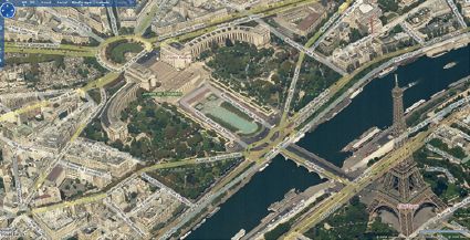
January’s Virtual Earth imagery update includes a total 37 terabytes of data, Microsoft’s first use of Digital Globe satellite imagery, and, among other things, bird’s-eye imagery for Paris and other French cities (see also, naturally, GeoInWeb.
In other Microsoft mapping news, Live Maps India has been updated, and Microsoft has expanded its business agreement with NAVTEQ. (You will recall that Google is increasingly a Tele Atlas shop; James has noticed the sides lining up.)
Update: Also, Belgium, in typically Belgian distinct Flemish and French versions.

Comments
blog comments powered by Disqus