Mapping Galaxies to Two Billion Light Years
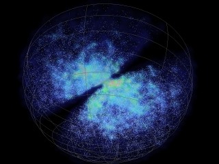 The Six-Degree Field Galaxy Survey has released a map showing the position and clustering patterns of more than 100,000 nearby galaxies — of course, by “nearby,” they mean “within two billion light years.” The map, which covers 80 percent of the southern sky, is the result of the Survey’s work mapping the redshifts of these galaxies between 2001 and 2005, using the Anglo-Australian Observatory’s 1.5-metre UK Schmidt telescope. At the scale to which I’ve reduced the map’s image at right, one pixel equals nearly five megaparsecs — almost certainly the smallest scale we will ever see. My head just exploded.
Press release, Astronomy, Universe Today.
(Update: In case you’re curious, the scale above is roughly 1:1.1×10¹⁹, or one to eleven quintillion.)

Comments
blog comments powered by Disqus