Mapping North Korea
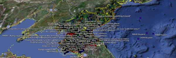
North Korea is very much in the news lately, but very much not on the map. The North Korea Uncovered project is trying to do something about that: it’s a Google Earth layer (KMZ file) that maps installations, landmarks and facilities inside the secretive country. The Wall Street Journal explains how the people behind the project compile their data: “Seeking clues in photos, news reports and eyewitness accounts, they affix labels to North Korean structures and landscapes captured by Google Earth, an online service that stitches satellite pictures into a virtual globe. The result is an annotated North Korea of rocket-launch sites, prison camps and elite palaces on white-sand beaches.” Via Kottke.
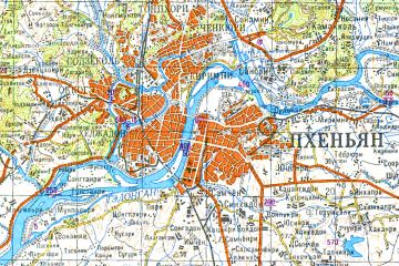 Meanwhile, 1:200,000-scale topographic maps of North Korea are now available, if you don’t mind that they’re in Russian and date from the mid-1980s. They come in a massive 129-megabyte zip file that includes plenty of file formats for geospatial professionals, but mere mortals will be able to use the GIFs. Via Free Geography Tools.

Comments
blog comments powered by Disqus