New Digital Elevation Model Covers 99 Percent of the Earth
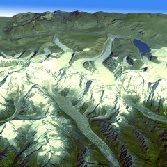 A new digital terrain map for the planet is now available. Based on imagery from the Japanese ASTER instrument on NASA’s Terra satellite, the new global digital elevation model covers 99 percent of the Earth’s landmass to a resolution of 30 metres; the previous digital elevation model, the Shuttle Radar Topography Mission, covered 80 percent of the Earth’s surface. The data itself is available here and here. See NASA’s press release plus sample images (one of which, showing the Himalayas in Bhutan, is reproduced at right). News coverage at Astronomy, BBC News and Universe Today. Via Gizmodo and MAPS-L.

Comments
blog comments powered by Disqus