1858 Map of Cape Cod Republished as Book
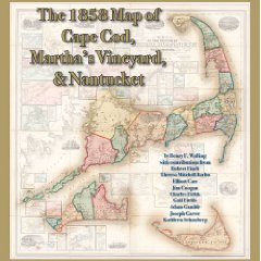 Henry Walling’s five-foot-square “Map of the Counties of Barnstable, Dukes and Nantucket, Massachusetts,” produced in 1858, is now available as a hardcover book, the Cape Cod Times reports: “The new book’s maps were shot digitally by Truro photographer Charles Fields, turning each section of the map into a 12-inch-by-12-inch page. Gail Fields helped design the book. Then local authors and artisans Robert Finch, Theresa Mitchell Barbo, Elliott Carr, Jim Coogan, Adam Gamble — the book’s co-publisher — and Cape Cod Community College President Kathleen Schatzberg added comments and short essays.”
- Buy The 1858 Map of Cape Cod, Martha’s Vineyard, & Nantucket at Amazon.com

Comments
blog comments powered by Disqus