Review: Paris Underground
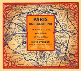
Paris Underground: The Maps, Stations, and Design of the Métro
by Mark Ovenden
Penguin, 2009. Softcover, 176 pp. ISBN 978-0-14-311639-4
 It’s possible that I know the Paris Métro better than any other subway system in the world. In the summer of 1997, I spent six weeks in Paris as a research assistant for my Ph.D. supervisor. Where I worked was close enough to where I stayed for me to walk to work each morning; even so, I dutifully bought a Carte orange for the month of June (plus a couple of Cartes hebdomadaires for July) and, during my time off, set about exploring Paris’s underground rail network, which in 1997 comprised 15 subway and four RER lines (counting 3bis and 7bis; line 14 and RER line E were still a year or two off).
Because I stayed at the Cité universitaire in the 14th arrondissement, my point of entry to the network was the eponymous station on the RER B line. From there, it was usually a rapid jaunt to one of the massive transfer points along the B line — usually Saint-Michel—Notre-Dame or Châtelet—Les Halles — where I would transfer to the numbered Métro lines. I took the RER wherever possible: their airy, spacious stations were far more easy to take for someone as crowd-averse as me than the older stations of the original network, and the trains were often hot and uncomfortable during the summer.
Somehow I never picked up one of the RATP’s official maps of the network; instead, I made do with my Michelin Plan de Paris, whose Métro map was woefully inadequate but which helpfully pointed out station entrances on its 1:10,000-scale neighbourhood-level maps. Otherwise, I consulted the maps at each station — there were plenty of these, including geographical and diagrammatic network maps (including network maps that would light up your route to the desired station at the push of a button), regional maps that showed the RER network extending deep into the suburbs, and maps of the surrounding neighbourhood — a godsend for a prairie kid used to right-angle street blocks, thoroughly disoriented by Parisian streets and considerable time underground (my Michelin Plan helped there too).
My time spent in Paris, my background as a French historian, and my known affection for all things cartographical (to say nothing of a minor jones for trains) made me all too susceptible to a book like Mark Ovenden’s Paris Underground (which, incidentally, first saw print in the U.K. in 2008 as Paris Métro Style in Map and Station Design; Penguin Books is publishing the North American edition in 2009).
Paris Underground is not a map book per se, although maps of the Paris Métro illustrate the book throughout, and maps are certainly the book’s primary concern. If anything, the book is too ambitious, trying in one fell 176-page swoop to cover the history of the Métro, its construction, and the style and design language used by its maps and its stations. (Let me put it this way: fonts are discussed. Frequently.) For a taste of the non-map content, see this brief video by the author:
But there’s more than enough to satisfy the cartographic nerds as well. There are maps in this book from the late 19th century that predate the construction of the Métro by several decades, and maps of the network at virtually every stage of development. Maps are used as a way to show the history of the Métro network: each new edition showing progressively more and more completed. The text itself is pretty bare bones, and could be clearer at certain points; it can largely be seen as providing the necessary context to understand what the maps are showing.
Paris Underground is also concerned with how the Paris Métro has been mapped. The Paris Métro is easily the densest subterranean transit network on the planet: lines crisscross and overlap. It’s a challenge to present a map that shows each line clearly — even more so when maps weren’t printed in colour. There are lots and lots of examples from every period — three “bis” chapters look at unofficial commercial maps — and, as a result, lots and lots of attempts at mapping the system.
Most interesting is how much, until rather recently, the maps have largely followed geography, rather than adopting a network diagram in the style of Harry Beck’s London Underground map. Chapter 13 covers attempts at a diagrammatic map of the Paris network, including a couple by Harry Beck himself. While the RATP has adopted diagrammatic maps for inside its cars and as pocket maps — to say nothing of RER network maps that would be illegible and unwieldy if they were strictly geographic — a single, unified Beck-type diagram has not emerged, and geographic maps continue to be used, for example in stations.
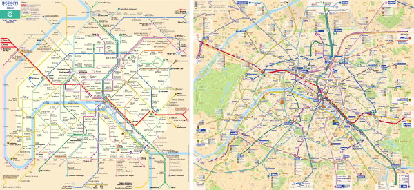
What emerges from Paris Underground is the extreme diversity of mapping that has been undertaken, even from official sources (even as they were standardizing colours for each line, as well as fonts). Mapping the Paris Métro has been an ongoing experiment for decades, the result of some serious cartographic challenges (a dense system map, the need to produce a system map that is recognizably of Paris) and yielding some awfully interesting maps in the process.
Like the Paris Métro and its maps, Paris Underground is dense and crowded and has far too much crammed into it: it could easily have been twice as long or half as comprehensive — and a lot more concise. But then it wouldn’t be quite as quintessentially Parisian, nor nearly as much fun.
Previously: Paris Underground; Harry Beck’s Map of the Paris Metro.
- Buy Paris Underground at Amazon.com

Comments
blog comments powered by Disqus