Fifty Equal U.S. States
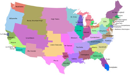 Neil Freeman’s map imagining 50 U.S. states with equal populations, thereby equalizing congressional overrepresentation from small states and rural areas, is making the rounds of the blogosphere (and Twitterverse™) lately (see, for example, here); we first saw it five years ago, in Martin’s comment on this entry about maps with what-if political boundaries. Not that it isn’t worth unearthing for another look. Thanks to James for the tip.
Previously: Question: What-If Political Boundaries?; Pearcy’s 38 States.

Comments
blog comments powered by Disqus