Haitian Earthquake: Links for January 15
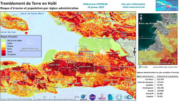
SERVIR produces maps and data for Central America and the Caribbean, including maps for disaster support. Maps of the Haitian earthquake produced to date include damage assessments from satellite imagery, including damage to Port-au-Prince’s seaport, and a map showing erosion risk (above) — no small thing where hillside buildings have collapsed. Thanks to Francisco Delgado for the link.
Ryan Strynatka demonstrates what it would be like to set up a GIS of the Haitian earthquake in the field. “Nothing fancy: I just wanted to see how long it would take and if it would be challenging to pull together base mapping data and then view it all together. No real geoprocessing, but just data acquisition and setup using open source software and publicly available data. This would be a similar to real-world workflows one could use for in-the-field mapping applications.” The result? “This workflow isn’t very sophisticated, but it does demonstrate the ability to get up and running relatively quickly. SRTM and OSM data are both invaluable resources – ideal for humanitarian work in disaster areas. As for the timing: if you know where to get the data, I think the simple example above could be completed in under an hour. That includes software installation, data downloads, and then assembling the data in a GIS.” Via Slashgeo. Previously: Field Guide to Humanitarian Mapping.
Catholicgauze points to a basic tool that supplies earthquake intensity data for a given address in Haiti.
Previously: ESA Satellite Imagery of Port-au-Prince; Mapping the Destruction in Port-au-Prince; Mapping the Haitian Earthquake.

Comments
blog comments powered by Disqus